Val di Nos e Monte Longara
 Naturalistici


Descrizione
E’ la Valle, che ha la sua testata nei pressi delle “Busette” di Gallio e la sua parte terminale nel territorio posto fra Gallio e Asiago così da lambire il greto del torrente Ghelpach; essa scorre da nord a sud fra due versanti, che generano un fondovalle dapprima stretto e angusto, poi assai ampio e spazioso, che i galliesi chiamano “Bathal” (dal cimbro “la valle dei muretti a secco”), e infine si restringe per scendere dolcemente lungo il cosiddetto “Gastagh Longo”.
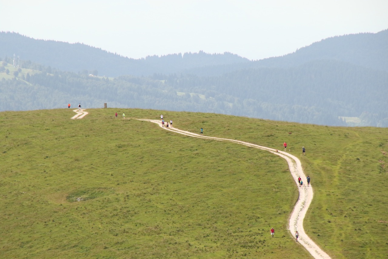
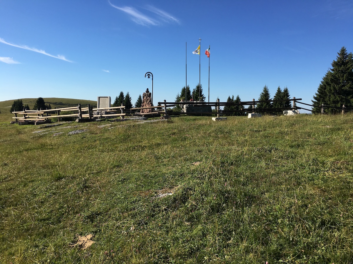
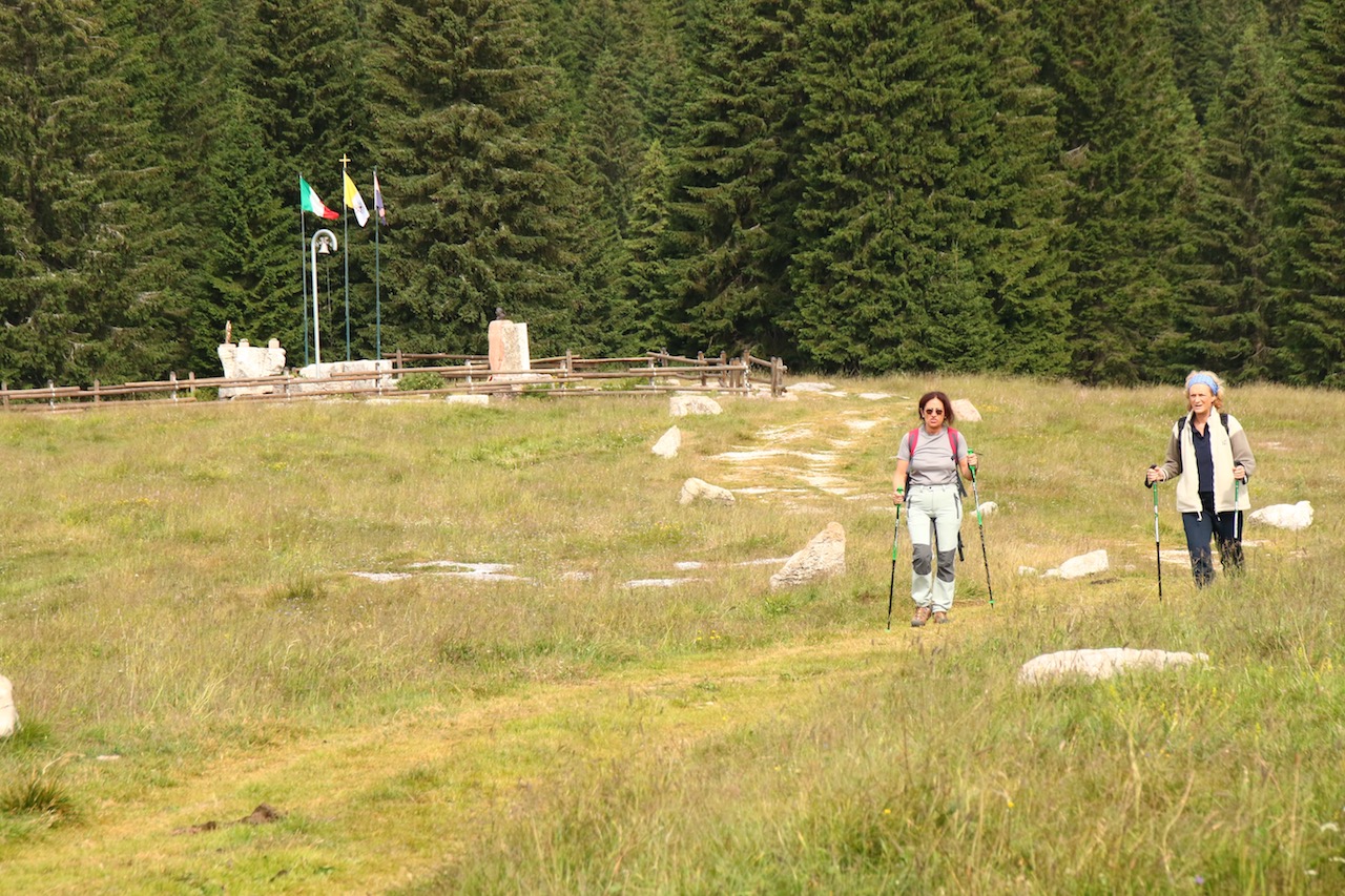
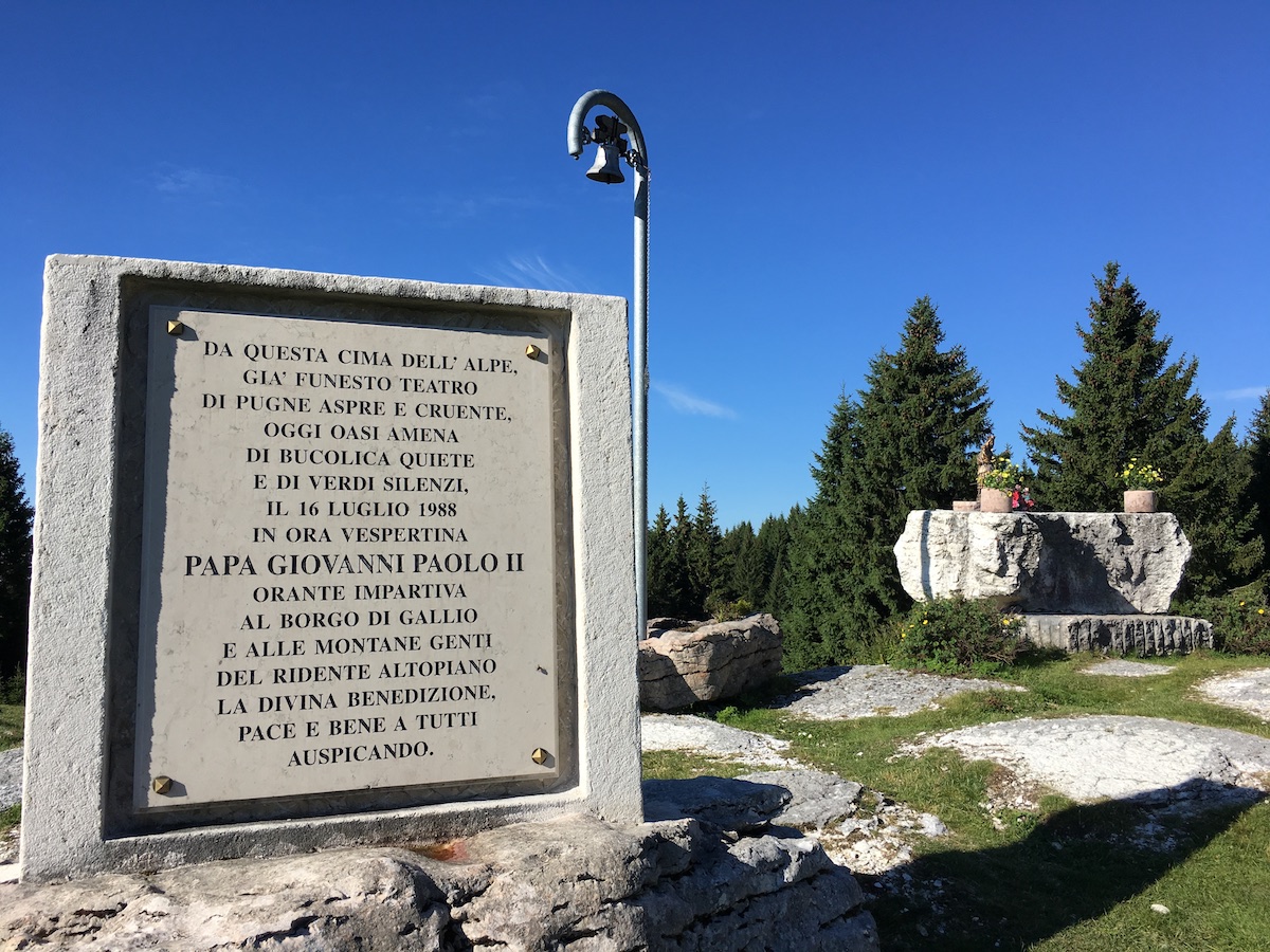
Per arrivarci si parte dal centro di Gallio, si percorre la strada che porta alla Valle del Pakstall e poi sale fino alla antica Contrada Costa per immettersi dopo l’ultima casa nella mulattiera, che raggiunge il valico dello Skalch e ridiscende fino all’acquedotto e al Capitello in Contrada Xebbo. Si attraversa la strada asfaltata e si sale fino all’ultima casa, che si lascia sulla destra per seguire la mulattiera, che giunge al limitare del bosco di abeti. Si prosegue su strada bianca fino a “Passo Stretto” e oltre per toccare dapprima il cosiddetto “Cimitero dell’Etzenplatten” (dal cimbro “pascolo su fondo roccioso”)e poi successivamente la località “Quattro strade”. Prendendo a destra si sale lungo una mulattiera a tornanti volgarmente chiamata “Claff” (dal cimbro “soffione”, fiore del tarassaco), che raggiunge un pianoro in prossimità di Malga Fiaretta; prendendo a destra si raggiunge Monte Ongara di Dietro, dove s’innalza il monumento-altare in onore di Papa Giovanni Paolo II eretto in ricordo della sosta del Pontefice in questa località avvenuta il 16 luglio 1988. Proseguendo, si raggiunge Malga Ongara di Dietro, da dove si può ammirare un panorama amplissimo, che comprende l’intero Altopiano meridionale, l’acrocoro settentrionale con l’Ortigara e Cima XII e ancora più a nord le affascinanti vette delle Dolomiti del Brenta. Proseguendo lungo il crinale in direzione Malga Ongara Davanti si viene spesso accompagnati dalle tristi vestigia della Grande Guerra, che qui ha lasciato segni indelebili, nonostante siano trascorsi da allora cent’anni: trincee, camminamenti, gallerie, ricoveri e buche di granate. Oltrepassata Malga Ongara Davanti il sentiero discende verso la Croce dell’Ongara e, quindi, alla località “luft” (dal cimbro “vento”) per arrivare infine alla Contrada Costa e al centro di Gallio. Il percorso presenta realtà storico-ambientali notevoli. Intanto la Valle è di origine glaciale, come lo dimostrano i ghiaioni morenici, i grossi massi erratici disseminati un po’ ovunque lungo la valle e le consistenti sedimentazioni sabbiose che affiorano soprattutto nel tratto chiamato “Bathal”. Inoltre nelle abetaie, che ricoprono i fianchi della valle, è facile incontrare il timido capriolo, il maestoso cervo, la veloce lepre e il furtivo tasso, oltre a una straordinaria varietà di fiori e funghi. Dal punto di vista storico si ricordi che la Valle vide nella primavera del 1916 l’insediamento di numerosi reparti dell’esercito austro-ungarico, che proprio da qui presero le mosse per invadere l’Altopiano fino a Marcesina per poi ritirarsi su una linea più facilmente difendibile, che correva dall’Ortigara fino al Cengio. Della presenza austro-ungarica fa fede il Cimitero dell’Etzenplatten, che i Galliesi chiamano “Cimitero dei Turchi” in quanto vi furono sepolti accanto a 1646 soldati italiani anche 485 soldati bosniaci di religione mussulmana.
This Valley begins near the Busette of Gallio and ends in the territory between Gallio and Asiago touching the bank of the Ghelpach stream; it runs from north to south between two sides creating a valley floor which is initially narrow and cramped, then wide and spacious , and finally narrow again to gently go down along the so-called Gastagh Longo.
To get there we leave from the center of Gallio, drive along the road leading to the Pakstall Valley and then climb up to the old Contrada Costa to take, after the last house, the mule track which reaches the Skalch pass and goes down back to the aqueduct and the tiny chapel in Contrada Xebbo. You cross the paved road and climb up to the last house, which you leave on the right to follow the track leading to the edge of the fir forest. Continue on an unpaved road to Passo Stretto to first reach the so-called Etzenplatten Cemetery ("pasture on a rocky background" in Cimbrian ancient language) and then the Four Streets village. Turning right, you climb up a track with hairpin turns called Claff (the "dandelion flower"), which reaches a plateau near Malga Fiaretta; taking the right track, you reach Mount Ongara di Dietro, where the altar-monument stands in honor of Pope John Paul II, in memory of the Pope’s stay in this town on July 16, 1988. Continuing, you reach Malga Ongara di Dietro, where you can admire a huge panorama which includes the whole southern side of the plateau, the northern massif with Ortigara and Cima XII and even the fascinating peaks of the Brenta Dolomites. Continuing along the ridge in the direction of Malga Ongara Davanti you are often accompanied by the sad remains of the Great War, which have left here indelible signs, despite having passed one hundred years: trenches, walkways, galleries, shelters and grenade holes. Overpassed Malga Ongara Davanti the path climbs down to the Cross of Ongara and then to the luft ( "wind") to finally arrive at Contrada Costa and in the center of Gallio. The trail presents many historical and environmental remarkable sites. Indeed, the Valley is of glacial origin, as demonstrated by the morainic screes, the large erratic boulders scattered all along the valley and the vast sandy sediments that emerge especially in the stretch called “Bathal". In addition, in the fir tree forests covering the valley's sides, it is easy to meet the timid roe deer, the majestic deer, the fast hare and the stealthy badger, as well as an extraordinary variety of flowers and mushrooms. Historically, in the spring of 1916, the Valley witnessed the establishment of numerous Austro-Hungarian army departments which moved from here to invade the Plateau up to Marcesina and then retreat to a more easily defendable new line, running from Ortigara to Cengio. The presence of Austro-Hungarian troops is evident in the cemetery of the Etzenplatten, which local people call "Cemetary of the Turks", as alongside 1646 Italian soldiers there were buried also 485 Bosnian soldiers of Muslim religion.